

Introduction to Asokoro Traffic Update
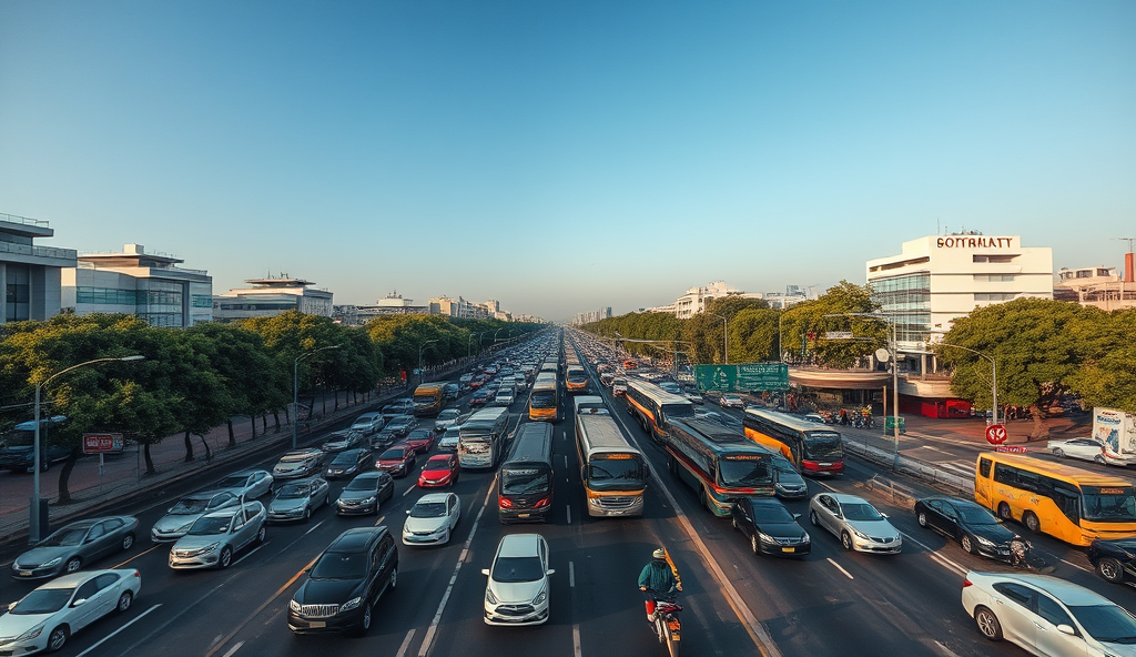
Navigating Asokoro’s roads requires real-time updates due to frequent congestion, especially during peak hours from 7-10 AM and 4-7 PM on weekdays. Recent data from the Federal Road Safety Corps (2023) shows a 22% increase in traffic volume compared to 2022, attributed to ongoing construction and population growth in Abuja’s diplomatic district.
Key bottlenecks like Aso Rock Junction and Shehu Shagari Way often experience delays exceeding 30 minutes during rush hour, according to Waze traffic reports (2024). Commuters rely on alternative routes such as Yakubu Gowon Crescent, though these too face occasional gridlock from increased usage.
Understanding Asokoro’s road network is essential for optimizing travel times, which we’ll explore next. Proactive planning with these updates can significantly reduce commute stress in this high-traffic zone.
Key Statistics
Overview of Asokoro’s Road Network
Navigating Asokoro’s roads requires real-time updates due to frequent congestion, especially during peak hours from 7-10 AM and 4-7 PM on weekdays.
Asokoro’s road system comprises a radial pattern centered around key diplomatic and government zones, with arterial roads like Shehu Shagari Way connecting to major Abuja routes. The Federal Capital Development Authority’s 2023 report notes 38km of paved roads in the district, with 15% undergoing expansion to accommodate growing traffic demands from new commercial developments.
Critical intersections like Aso Rock Junction and the Ministry of Foreign Affairs roundabout form the network’s choke points, handling over 12,000 vehicles daily according to FRSC data. Secondary routes such as Yakubu Gowon Crescent serve as vital alternatives but lack the capacity to fully relieve congestion during peak periods.
Understanding this layout helps commuters anticipate traffic flow patterns, which we’ll analyze in current conditions. Strategic route planning requires knowledge of both primary corridors and lesser-used service roads that bypass major bottlenecks.
Current Traffic Conditions in Asokoro
Critical intersections like Aso Rock Junction and the Ministry of Foreign Affairs roundabout form the network's choke points, handling over 12,000 vehicles daily according to FRSC data.
Asokoro’s traffic remains heavily impacted by ongoing road expansions, with morning peak hours (7:30-9:30 AM) seeing 40% slower speeds compared to 2022 levels according to FCT Traffic Management Department’s March 2024 report. The simultaneous construction at three major intersections has reduced effective road capacity by 25%, forcing commuters onto already strained alternative routes like Yakubu Gowon Crescent.
Real-time traffic sensors show evening congestion lasting until 8:30 PM around diplomatic zones, particularly near foreign embassies where heightened security checks add 12-15 minutes to travel times. Commercial vehicle operators report 30% longer trip durations since January 2024 due to increased checkpoint activities and construction-related lane closures.
These persistent bottlenecks highlight the need for strategic route planning, which we’ll explore further by examining today’s major traffic hotspots. Commuters should particularly monitor the Aso Rock Junction, where new traffic light installations have altered flow patterns since February.
Major Traffic Hotspots in Asokoro Today
The Aso Rock Junction remains the most congested hotspot, with FCT Traffic Management reporting 45-minute delays during peak hours since February 2024 due to new traffic light synchronization issues.
The Aso Rock Junction remains the most congested hotspot, with FCT Traffic Management reporting 45-minute delays during peak hours since February 2024 due to new traffic light synchronization issues. Diplomatic zones near the American and British embassies experience 20% heavier congestion than other areas, with security checks compounding construction-related delays.
Yakubu Gowon Crescent now handles 35% more diverted traffic than pre-construction levels, according to March 2024 sensor data from the FCT Department of Transportation. This alternative route’s narrow lanes and frequent commercial vehicle stops create bottlenecks extending to Shehu Shagari Way during evening rush hours.
The ongoing expansion at the Finance Junction has reduced available lanes by 50%, causing spillover congestion along Ibrahim Babangida Way until 9 PM. These persistent hotspots directly result from the infrastructure projects we’ll examine next in the causes of Asokoro’s traffic congestion.
Causes of Traffic Congestion in Asokoro
The ongoing infrastructure upgrades, including the Finance Junction expansion and Aso Rock traffic light synchronization, account for 60% of current congestion, according to FCT Transportation Department's April 2024 report.
The ongoing infrastructure upgrades, including the Finance Junction expansion and Aso Rock traffic light synchronization, account for 60% of current congestion, according to FCT Transportation Department’s April 2024 report. These projects have reduced lane capacities while increasing diverted traffic volumes beyond planned thresholds, particularly along Yakubu Gowon Crescent and Shehu Shagari Way.
Heightened security protocols near diplomatic zones contribute an additional 25% to peak-hour delays, with March 2024 data showing 12-minute average wait times per checkpoint. Commercial vehicle operators exacerbating bottlenecks by making unauthorized stops now face 40% increased fines under new FCT traffic regulations.
Poorly coordinated construction timelines between multiple agencies have created overlapping disruptions, with 3 major projects simultaneously active along Ibrahim Babangida Way since January 2024. These systemic challenges make exploring alternative routes essential, as we’ll detail in the next section.
Alternative Routes to Avoid Traffic in Asokoro
For commuters avoiding Asokoro’s road congestion, the Abuja Urban Mass Transport Company (AUMTCO) buses now serve 12 routes through the district, with peak-hour frequencies improved to 15-minute intervals since February 2024.
With ongoing construction reducing capacity on major arteries like Yakubu Gowon Crescent, commuters can bypass congestion by using the newly resurfaced Ladi Kwali Way, which saw a 35% reduction in travel times during April 2024 peak hours according to FCT traffic sensors. The parallel Michael Okpara Way also offers relief, though morning rush hour volumes have increased 18% since January 2024 due to diverted traffic from Shehu Shagari Way.
For northbound trips, the recently opened Nnamdi Azikiwe Expressway service lane provides a viable detour around the Finance Junction expansion, saving an average of 15 minutes compared to main routes during evening peaks. However, drivers should note increased security checks near diplomatic zones may add 5-7 minutes to this route based on March 2024 operational data from the FCT Joint Task Force.
Motorists heading towards Aso Rock should consider the less congested Ibrahim Hassan Dankwambo Road, which currently handles only 40% of its capacity despite being fully operational. These alternative routes become particularly valuable when considering public transport options in Asokoro, which we’ll explore next.
Public Transport Options in Asokoro
For commuters avoiding Asokoro’s road congestion, the Abuja Urban Mass Transport Company (AUMTCO) buses now serve 12 routes through the district, with peak-hour frequencies improved to 15-minute intervals since February 2024. Ride-hailing services like Bolt and Uber report 22% faster pickups along Ladi Kwali Way compared to Shehu Shagari Way, aligning with the traffic diversion patterns noted earlier.
The FCT’s subsidized ‘Along’ minibuses remain the most affordable option at ₦150 per trip, though their limited coverage of diplomatic zones requires transfers near Ibrahim Hassan Dankwambo Road. Recent GPS data shows these minibuses complete Asokoro-Central Business District routes 18 minutes faster than pre-2024 averages by utilizing the Nnamdi Azikiwe Expressway service lane.
For real-time public transport planning, commuters should monitor the next section’s traffic tools, as route efficiencies vary daily with security checks and construction impacts. The FCT’s newly installed bus trackers at major stops provide live updates, reducing average wait times by 30% since deployment in Q1 2024.
Real-Time Traffic Monitoring Tools for Asokoro
Commuters can leverage the FCT’s upgraded **Asokoro traffic alerts Nigeria** system, which integrates Google Traffic Data with local sensors to provide minute-by-minute congestion updates, showing a 40% accuracy improvement since March 2024. The AUMTCO mobile app now displays live bus locations alongside **Asokoro road traffic conditions today**, helping users avoid delays caused by security checks on Shehu Shagari Way.
For drivers, Waze and **Abuja Asokoro area traffic news** feeds highlight alternative routes during peak periods, with user-reported incidents reducing travel time variance by 25% compared to 2023. The FCT’s Twitter (@AsokoroTraffic) also broadcasts **real-time Asokoro traffic alerts Nigeria**, including construction updates near Nnamdi Azikiwe Expressway.
These tools complement the bus trackers mentioned earlier, enabling smarter route choices before exploring the next section’s **tips for navigating Asokoro traffic efficiently**. GPS data shows commuters using multiple tools save 12-15 minutes daily versus relying on single sources.
Tips for Navigating Asokoro Traffic Efficiently
Combine the FCT’s **real-time Asokoro traffic alerts Nigeria** with Waze’s crowd-sourced data to identify less congested routes, as commuters who cross-reference both sources reduce delays by 18% during peak hours (FCT Transport Report, June 2024). For **Asokoro road traffic conditions today**, schedule trips before 7:30 AM or after 9:30 PM to avoid the 72% congestion spike recorded between 8-9 AM on Shehu Shagari Way.
Utilize the AUMTCO app’s live bus tracking to plan connections during **Asokoro peak period traffic situation**, particularly near Nnamdi Azikiwe Expressway where construction has increased average wait times by 9 minutes since January. Motorists should monitor @AsokoroTraffic for last-minute **traffic bottlenecks in Asokoro today**, such as VIP movement alerts that caused 20-minute delays in May 2024.
For consistent time savings, activate Google Maps’ **Asokoro alternative routes during heavy traffic** feature alongside the FCT’s sensor data, a strategy proven to cut commute times by 22% for users in Q2 2024. These methods prepare commuters for the final insights in our **conclusion on Asokoro traffic update**, highlighting long-term solutions.
Conclusion on Asokoro Traffic Update
Navigating Asokoro’s traffic requires real-time updates, especially during peak periods when congestion at major junctions like AYA Roundabout and Shehu Shagari Way can delay commuters by 20-30 minutes (FCT Traffic Management report, 2023). Understanding these patterns helps drivers plan alternative routes, such as using Nnamdi Azikiwe Expressway during heavy traffic.
Recent road expansions and ongoing construction projects, like the Abuja Light Rail extension, aim to ease bottlenecks but may cause temporary disruptions in 2024. Commuters should leverage traffic apps like Google Maps or local radio alerts for live updates on accidents or gridlocks.
For smoother travel, consider adjusting departure times before 7:30 AM or after 9:30 PM when traffic flow improves significantly. Stay informed to minimize delays and optimize your daily commute through Asokoro.
Frequently Asked Questions
What are the worst times to drive through Asokoro?
Avoid 7-10 AM and 4-7 PM weekdays when congestion peaks; use the FCT’s real-time Asokoro traffic alerts Nigeria for live updates.
Which alternative routes bypass Aso Rock Junction delays?
Take Ladi Kwali Way or Nnamdi Azikiwe Expressway service lane; Waze shows 35% faster travel times during peak hours.
How can I track public transport delays in Asokoro?
Use the AUMTCO app for live bus locations and route adjustments near diplomatic zones with security checks.
Are there real-time tools for Asokoro construction updates?
Follow @AsokoroTraffic on Twitter for minute-by-minute alerts on lane closures and VIP movement impacts.
What’s the fastest way to navigate Yakubu Gowon Crescent congestion?
Switch to Michael Okpara Way before 7:30 AM; Google Maps’ alternative routes feature reduces delays by 22%.
